Iklan

Search Engine

Custom Search
Showing posts with label global. Show all posts

Sunday, June 5, 2016

High Temperatures In Arctic

0-2000 m Global Ocean Heat Content
Ocean heat content is rising, as illustrated by the image on the right. Where the sea ice declines, this is causing high air temperatures in the Arctic.

This year (from January to April 2016) on the Northern Hemisphere, oceans were 0.85°C or 1.53°F warmer than the 20th century average.

The image below illustrates that temperatures look set to be high in Siberia for the coming week. The panel on the right shows anomalies at the top end of the scale in Eastern Siberia on June 5, 2016, while the panel on the right shows a forecast for June 12, 2016.


These high air temperatures are causing feedbacks that are in turn further speeding up warming in the Arctic.

This is illustrated by the images below. The image directly below shows temperatures in Eastern Siberia as high as 29.5°C (85°F) on June 5, 2016, at a location close to the coast of the Arctic Ocean (green circle).


High air temperatures come with increased risk of wildfires, as illustrated by the image below showing carbon monoxide levels as high as 2944 ppb on June 4, 2016 (at green circle).


The satellite image below zooms into the area with these high carbon monoxide readings, showing wildfires on Kamchatka Peninsula on June 3, 2016.


High air temperatures in the Arctic are very worrying, as they can trigger a number of important feedbacks, including:
  • Changes to Jet Streams. As the Arctic warms more rapidly than the rest of Earth, changes are occurring to the jet streams. As a result, winds can increasingly bring hot air far to the north, resulting in further loss of the Arctic snow and ice cover, in turn further warming up the Arctic.
  • Warmer Rivers. High air temperatures cause warming of the water of rivers that end up in the Arctic Ocean, thus resulting in additional sea ice decline and warming of the Arctic Ocean all the way down to the seabed.
  • Wildfires. High air temperatures set the scene for wildfires that emit not only greenhouse gases such as carbon dioxide and methane, but also pollutants such as carbon monoxide (that depletes hydroxyl that could otherwise break down methane) and black carbon (that when settling on ice causes it to absorb more sunlight).
  • Soil destabilization. Heatwaves and droughts destabilize the soil. Soil that was previously known as permafrost, was until now held together by ice. As the ice melts, organic material in the soil starts decomposing, resulting in emissions of methane and carbon dioxide, while the soil becomes increasingly vulnerable to wildfires.
  • Buffer Loss. Arctic snow and ice cover acts as a buffer, absorbing heat that in the absence of this buffer will have to be absorbed by the Arctic Ocean.
  • Albedo Change. Arctic snow and ice cover also make that more sunlight is reflected back into space. In the absence of this cover, the Arctic will have to absorb more heat.

How rapidly can things eventuate?

Professor Peter Wadhams, head of the Polar Ocean Physics Group at Cambridge University, says: “My prediction remains that the Arctic ice may well disappear, that is, have an area of less than one million square kilometres for September of this year.” Warming due to Arctic snow and ice loss may well exceed 2 W per square meter, i.e. it could more than double the net warming now caused by all emissions by people of the world, Peter Wadhams calculated in 2012.

Peter Wadhams further co-authored a study that calculated that methane release from the seafloor of the Arctic Ocean could yield 0.6°C warming of the planet in 5 years (see video interview of Thom Hartmann with Peter Wadhams below).


The two feedbacks mentioned by Peter Wadham (albedo and seafloor methane) are are depicted in the image below.

for further discussion, see the feedbacks page
The combined global temperature rise over the next decade due to these two feedbacks (albedo and seafloor methane) alone may be 0.4°C or 0.72°F for a low-rise scenario and may be 2.7°C or 4.9°F for a high-rise scenario. Additionally, as temperatures rise, further feedbacks will kick in more strongly, further accelerating the rise in temperature, as discussed in earlier posts such as this one.

In total, warming could exceed 10°C (18°F) within one decade, assuming that no geoengineering will take place within a decade, as discussed in earlier posts such as this one.

The situation is dire and calls for comprehensive and effective action, as described at the Climate Plan.

Links

- Feedbacks in the Arctic
http://arctic-news.blogspot.com/p/feedbacks.html

- East Siberian Heatwave
http://arctic-news.blogspot.com/2015/07/east-siberian-heat-wave.html

- Wildfire Danger Increasing
http://arctic-news.blogspot.com/2016/05/wildfire-danger-increasing.html

- Albedo changes in the Arctic
http://arctic-news.blogspot.com/2012/07/albedo-change-in-arctic.html

- Three kinds of warming in the Arctic
http://arctic-news.blogspot.com/2016/02/three-kinds-of-warming-in-arctic.html

- Arctic could become ice-free for first time in more than 100,000 years, claims leading scientist
http://www.independent.co.uk/environment/climate-change/arctic-could-become-ice-free-for-first-time-in-more-than-100000-years-claims-leading-scientist-a7065781.html

- Greenhouse gas levels and temperatures keep rising
http://arctic-news.blogspot.com/2016/01/greenhouse-gas-levels-and-temperatures-keep-rising.html

- Arctic Methane Release: "Economic Time Bomb"
http://arctic-news.blogspot.com/2013/07/arctic-methane-release-economic-time-bomb.html

- February Temperature
http://arctic-news.blogspot.com/2016/03/february-temperature.html

- Ten Degrees Warmer In A Decade?http://arctic-news.blogspot.com/2016/03/ten-degrees-warmer-in-a-decade.html

- Climate Plan
http://arctic-news.blogspot.com/p/climateplan.html


Saturday, May 28, 2016

How Much Warming Have Humans Caused?

How much did temperatures rise?

Differences in baseline (reference period) can result in dramatic differences in temperature rise. The U.K. Met Office HadCRUT4 dataset typically presents temperature anomalies relative to a 1961-1990 baseline. NASA typically uses a 1951-1980 baseline, but the NASA website allows for different baselines to be selected. When selecting a 1961-1990 baseline, temperatures over the past half year were 1.05°C (1.89°F) higher than this baseline, as shown by the NASA map in the left panel of the image below. As the map in the right panel of the image below shows, when compared to 1890-1910, temperatures have risen by 1.48°C (or 2.664°F).


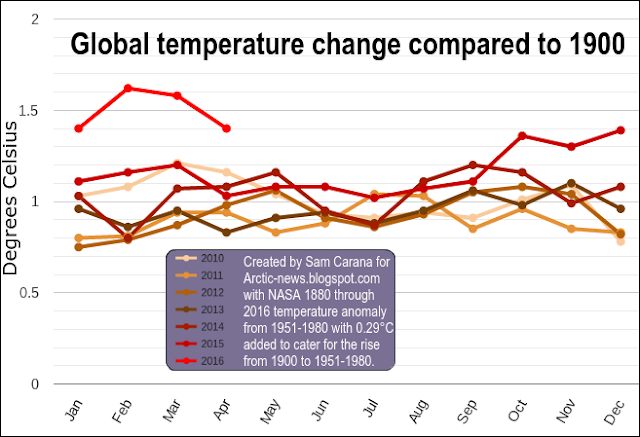
A polynomial trend can reduce variability such as caused by volcanoes and El Niño events. The graph below was created with the NASA L-OTI monthly mean global surface temperature anomaly, which has a 1951-1980 baseline, and then with 0.29°C added, which makes the anomaly 0°C in the year 1900 for the added polynomial trend.


This gives an idea of how much temperatures have risen since the year 1900, with a rise for both February and March 2016 showing up that was more than 1.5°C, as also illustrated by the image below. The trend further points at temperature anomalies that will be more than 1.5°C within a decade and more than 2°C soon thereafter.


Historical Temperatures


To calculate by how much warming humans have caused since pre-industrial times, we need to go back further than 1900. The graph below shows that carbon dioxide concentrations have gone up and down between roughly 180 ppm and 280 ppm over the past 800,000 years and did recently reach a peak of 411 ppm (peak hourly average on May 11, 2016).


The graph below, from an earlier post, shows how in the past, over the past 420,000 years, temperatures (and levels of CO2 and CH4) have gone up and down by some 10°C, in line with the Milankovitch cycles.


Historically, carbon dioxide rises of 100 ppm have gone hand in hand with temperature rises of some 10°C. The recent rise in carbon dioxide concentrations is a 131 ppm rise (from some 280 ppm to 411 ppm). The rise in methane concentrations is even steeper. Could we therefore expect a temperature rise of more than 10°C to happen, and if so how soon could this eventuate? As described below, warming caused by humans could result in a temperature rise of more than 10°C (18°F) within a decade.

The graph on the right, created by Jos Hagelaars, shows that, during the most current cycle, temperatures reached a peak some 7000 years ago (in the blue part of the graph).

The graph underneath, based on work by Marcott et al., focuses on this blue part of the graph, while using a 1961-1990 baseline. Temperatures reached a peak some 7000 years ago, and then came down to reach a low a few hundred years ago.

The peak and the bottom temperatures (highlighted in red on image) over the period suggest a fall of more than 0.7°C.

A few hundred years ago, temperatures were falling and they would have kept falling, in line with the Milankovitch cycles, had there been no warming caused by humans.

From that bottom point, temperatures first rose by about 0.4°C, overwhelming the downward trend that would otherwise have taken temperatures down further, and then there was an additional rise of at least 1.05°C, when using a baseline of 1961-1990. That may suggest that humans have caused a total of 1.45°C warming.

Humans have caused even more warming

The situation looks to be even worse than what the above figures may suggest. Indeed, the bottom low point in the Marcott graph would have been even lower had there been no warming by humans. 

Temperatures before 1900 were already higher than what they would have been had humans caused no warming. The fact that humans did cause substantial warming between 1800 and 1900 is illustrated by the graph below, from a recent post by Michael Mann, who adds that some 0.3°C greenhouse warming had already taken place between the year 1800 and the year 1900.
Some 0.3C greenhouse warming had already taken place by 1900, and some 0.2C warming by 1870
Further studies suggest that humans also caused substantial warming well before 1800, as illustrated by the image on the right. While this study focuses on Europe, it does suggest a rise from 1600 to 1800.

Another example of warming caused by humans before 1800 is presented in research by Dull et al., which suggests that burning of Neotropical forests increased steadily in the Americas, peaking at a time when Europeans arrived in the late fifteenth century. By 1650, some 95% of the indigenous population had perished. Regrowth of forests led to carbon sequestration of some 2 to 5 Pg C, thereby contributing to a fall in atmospheric carbon dioxide recorded in Antarctic ice cores from about 1500 through 1750.

Paris Agreement

NASA data suggest that it was 1.48°C (or 2.664°F) warmer than in 1890-1910 for the period from November 2015 to April 2016. Note again that this 1890-1910 baseline is much later than pre-industrial times. The Paris Agreement had pledged to limit the temperature rise to 1.5°C above pre-industrial levels. On land on the Northern Hemisphere, it was 1.99°C (or 3.582°F) warmer (right map of the image below).

[ Temperature anomalies for the period from November 2015 to April 2016, see also comments ]
The above images only account for a half-year period, so they are only indicative for the total rise for the year 2016. Nonetheless, when taking into account warming caused by people before 1900, the year 2016 looks set to exceed the guardrails that the Paris Agreement had pledged would not be crossed. The situation looks even worse when considering that temperatures measured in ice cores already included a substantial amount of warming due to humans even before the start of the Industrial Revolution.

February 2016 was 1.67°C (3°F) warmer than 1890-1910
Again, at the Paris Agreement nations pledged to hold the increase in the global average temperature to well below 2°C above pre-industrial levels and to pursue efforts to limit the temperature increase to 1.5°C above pre-industrial levels.

When looking at a single month, February 2016 was 1.67°C (3°F) warmer than 1890-1910 (see image right). When adding a mere 0.34°C to account for warming before 1900, total warming in February 2016 did exceed 2°C. Looking at it that way, the guardrails set in Paris in December 2015 were already crossed in February 2016.

Situation

So, what is the situation? On the one hand, there's the current observed temperature rise (∆O). This rise is typically calculated as the difference between the current temperature and the temperature at a given baseline.

However, this ∆O does not reflect the full impact of human emissions. Temperatures would have been lower had there been no emissions by humans. The full warming impact due to people's emissions therefore is ∆E. This ∆E is higher than the often-used observed rise, since the baseline would have been lower without warming caused by humans.

At the same time, part of global warming caused by people is currently masked due the aerosol emissions (∆A). Such aerosol emissions result from mainly burning of fossil fuel and biomass. There's no doubt that such emissions should be reduced, but the fact remains that the current temperature rise may increase substantially, say, by half when the masking effect disappears.

Thus, the full (unmasked) warming caused by humans is the sum of these two, i.e. ∆E + ∆A, and the sum could be as high as 3°C or even more than 5°C.

In addition, there is a future temperature rise that's already baked into the cake (∆F). Some feedbacks are not yet very noticeable, since some changes take time to become more manifest, such as melting of sea ice and non-linear changes due to feedbacks that are only now starting to kick in. Furthermore, the full effect of CO2 emissions reaches its peak only a decade after emission, while even with the best efforts, humans are likely to still be causing additional emissions over the coming decade. All such factors could jointly result in a temperature rise greater than ∆E + ∆A together, i.e. ∆F could alone cause a temperature rise of more than 5°C within a decade.

In summary, total warming caused by humans (∆E + ∆A + ∆F) could be more than 10°C (18°F) within one decade, assuming that no geoengineering will take place within a decade.

The situation is dire and calls for comprehensive and effective action as described in the Climate Plan.


Links

- Methane Erupting From East Siberian Arctic Shelf
http://arctic-news.blogspot.com/2014/11/methane-erupting-from-east-siberian-arctic-shelf.html

- Jos Hagelaars' graph, created with graphs by Shakun et al., Marcott et al. and more, is at:
https://ourchangingclimate.wordpress.com/2013/03/19/the-two-epochs-of-marcott/

- Global warming preceded by increasing carbon dioxide concentrations during the last deglaciation, by Shakun et al. http://www.nature.com/nature/journal/v484/n7392/full/nature10915.html

- A Reconstruction of Regional and Global Temperature for the Past 11,300 Years, by Marcott et al.
http://science.sciencemag.org/content/339/6124/1198

- The Columbian Encounter and the Little Ice Age: Abrupt Land Use Change, Fire, and Greenhouse Forcing, by Dull et al., in:
https://www.sciencenews.org/article/columbus-arrival-linked-carbon-dioxide-drop

- Arctic Climate Records Melting
http://arctic-news.blogspot.com/2016/05/arctic-climate-records-melting.html

- 2500 Years of European Climate Variability and Human Susceptibility, Ulf Büntgen et al. (2011)

Friday, March 11, 2016

Ten Degrees Warmer In A Decade?

In 2015, mean global carbon dioxide grew by 3.09 parts per million (ppm), more than in any year since the record started in 1959. An added polynomial trendline points at a growth of 5 ppm by 2026 (a decade from now) and of 6 ppm by 2029.

NOAA data, added trend points at 5 ppm growth a decade from now
There are a number of elements that determine how much the total temperature rise will be, say, a decade from now:

Rise 1900-2016: In January 2016, it was 1.92°C (3.46°F) warmer on land than in January 1890-1910, as discussed in an earlier post that also featured the image below.

Rise before 1900: Before 1900, temperature had already risen by ~0.3°C (0.54°F), as Dr. Michael Mann points out.

Rise 2016-2026: The image at the top shows a trend pointing at 5 ppm growth a decade from now. If levels of carbon dioxide and further greenhouse gases keep rising, then that will account for additional warming over the next ten years. Even with dramatic cuts in carbon dioxide emissions, temperatures will keep rising, as maximum warming occurs about one decade after a carbon dioxide emission, so the full wrath of the carbon dioxide emissions over the past ten years is still to come.

Removal of aerosols: With dramatic cuts in emissions, there will also be a dramatic fall in aerosols that currently mask the full warming of greenhouse gases. From 1850 to 2010, anthropogenic aerosols brought about a decrease of ∼2.53 K, says a recent paper. In addition, people will have emitted a lot more aerosols since 2010.

Albedo change: Warming due to Arctic snow and ice loss may well exceed 2 W per square meter, i.e. it could more than double the net warming now caused by all emissions by people of the world, calculated Professor Peter Wadhams in 2012.

Methane eruptions from the seafloor: ". . . we consider release of up to 50 Gt of predicted amount of hydrate storage as highly possible for abrupt release at any time," Dr. Natalia Shakhova et al. wrote in a paper presented at EGU General Assembly 2008. Authors found that such a release would cause 1.3°C warming by 2100. Note that such warming from an extra 50 Gt of methane seems conservative when considering that there now is only some 5 Gt of methane in the atmosphere, and over a period of ten years this 5 Gt is already responsible for more warming than all the carbon dioxide emitted by people since the start of the industrial revolution.

Water vapor feedback: Water vapour feedback acting alone approximately doubles the warming from what it would be for fixed water vapour. Furthermore, water vapour feedback acts to amplify other feedbacks in models, such as cloud feedback and ice albedo feedback. If cloud feedback is strongly positive, the water vapour feedback can lead to 3.5 times as much warming as would be the case if water vapour concentration were held fixed, according to the IPCC.

The image below puts these elements together in two scenarios, one with a relatively low temperature rise of 3.5°C (6.3°F) and another one with a relatively high temperature rise of 10°C (18°F).

Temperature rise on land a decade from now (without geoengineering)
Note that the above scenarios assume that no geoengineering will take place within a decade.
[ click on images to enlarge ]

As described above, the January 2016 temperature anomaly on land compared to January 1890-1910 was 1.92°C (3.46°F). Globally, the anomaly was 1.53°C (2.75°F), as shown by the image top right.

Putting the elements together for two global scenarios will result in a total rise of 3.11°C (5.6°F) for a relatively low global temperature rise and 9.61°C (17.3°F) for a relatively high global temperature rise, as shown by the image bottom right.

So, will climate catastrophe occur in a decade or later? There are many indications that the odds are large and growing rapidly. Some say climate catastrophe is inevitable or is already upon us. Others may like to believe the odds were rather small. Even so, the magnitude of the devastation makes it imperative to start taking comprehensive and effective action now.


The situation is dire and calls for comprehensive and effective action, as described in the Climate Plan.


In 2015, mean global CO2 grew by 3.09 parts per million, more than in any year since the record started in 1959. An...
Posted by Sam Carana on Wednesday, March 9, 2016

Friday, October 23, 2015

September 2015 Sea Surface Warmest On Record

Arctic Sea Ice Extent Growth Seals Off Arctic Ocean


Arctic sea ice increased rapidly in October 2015, after reaching its annual minimum in September. As the image below shows, the growing sea ice extent has effectively sealed off the Arctic Ocean from the atmosphere, resulting in less evaporation and heat transfer from the ocean to the atmosphere.

The Naval Research Laboratory 30-days animation (up to October 22, with forecast added up to October 30) on the right shows that sea ice has grown in extent, adding plenty of very thin sea ice, while the existing ice has hardly increased its thickness.

The Buffer Has Gone

Thick sea ice used to extend meters below the sea surface in the Arctic, where it could consume massive amounts of ocean heat through melting this ice into water. As such, thick sea ice acted as a buffer. Over the years, Arctic sea ice thickness has declined most dramatically. This means that the buffer that used to consume massive amounts of ocean heat carried by sea currents into the Arctic Ocean, has now largely gone.

Latent heat loss, feedback #14 on the Feedbacks page
Cold Freshwater Lid on North Atlantic

Meanwhile, especially from 2012, huge amounts of freshwater have run off Greenland, with the accumulated freshwater now covering a huge part of the North Atlantic, acting as a lid that prevents ocean heat to evaporate from the North Atlantic.


Since it's freshwater that is now covering a large part of the surface of the North Atlantic, it will not easily sink in the very salty water that was already there. The water in the North Atlantic was very salty due to the high evaporation, which was in turn due to high temperatures and strong winds and currents. Freshwater tends to stay on top of more salty water, even though the temperature of the freshwater is low, which makes this water more dense. The result of this stratification is less evaporation in the North Atlantic, and less transfer of ocean heat to the atmosphere, and thus lower air temperatures than would have been the case without this colder surface water.

Cold freshwater lid on North Atlantic, feedback #28 on the Feedbacks page
The cold lid over the North Atlantic has meanwhile expanded. Greenland has been experiencing wild weather swings this month, with temperatures shifting from one extreme end of the scale to the other end. The image below shows temperature anomalies on October 17 (left panel), October 23 (center panel) and a forecast for October 30 (right panel). Temperatures are forecast to swing back to the extreme high end of the scale, pushing up temperature anomalies for the Arctic as a whole to as high as 2.37°C on October 30, 2015.

Wild weather swings causing methane releases, feedback #21 on the Feedbacks page
These wild weather swings over Greenland threaten to cause cracks in the ice, with methane hydrates in the ice becoming destabilized, resulting in releases of huge amounts of methane from hydrates and free gas into the atmosphere, as earlier discussed as feedback #21 on the Feedbacks page.

Strong winds have further contributed to extend the cold lid over the North Atlantic, while also making cold air flow from Greenland over the North Atlantic. This is illustrated by the image below, depicting the situation on October 23, 2015, with the left panel showing surface wind speed, while the right panel shows the resulting sea surface temperature anomalies. 


The video below shows surface wind speed forecasts in the Arctic from October 25 to November 1, 2015.


Ocean Temperature Rise

NOAA analysis shows that the global sea surface in September 2015 was the warmest on record, at 0.81°C (1.46°F) above the 20th century average of 16.2°C (61.1°F). On the Northern Hemisphere, the anomaly was 1.07°C (1.93°F).

[ click on image to enlarge ]
Of all the excess heat resulting from people's emissions, 93.4% goes into oceans. Accordingly, the temperature of oceans has risen substantially over the years and - without action - the situation only looks set to get worse.

The Threat

As ocean temperatures continue to rise, especially in the North Atlantic, the Gulf Stream will keep carrying ever warmer water from the North Atlantic into the Arctic Ocean. Without the buffer of thick sea ice to consume the increasing amount of ocean heat, the threat is that ocean heat will increasingly reach the seafloor and unleash huge methane eruptions from destabilizing clathrates. Such large methane eruptions will then warm the atmosphere at first in hotspots over the Arctic and eventually around the globe, while also causing huge temperature swings and extreme weather events, contributing to increasing depletion of fresh water and food supply, as further illustrated by the image below, from an earlier post.
[ click on image at original post to enlarge ]

October 2015 Sea Surface Temperature Update

The North Atlantic continues to be very warm. Sea surface temperature anomalies were as high as 7.9°C or 14.2°F at a location off the east coast of North America on October 22, 2015. Anomalies were 8.1°C or 14.5°F at that same spot on October 16, 2015.


Sea surface temperature anomalies were as high as 7.5°C or 13.6°F at a location near Svalbard on October 25, 2015. On October 9, 2015, sea surface temperatures were as high as 13.1°C or 55.6°F at that same location near Svalbard (marked by green circle on image below), an anomaly of 9.5°C or 17.2°F. These temperatures indicate that the water can be much warmer below the surface than at the surface, and that this warm water is transported by the Gulf Stream below the surface of the North Atlantic into the Arctic Ocean. The animation below switches between the above two dates and also shows that the cold freshwater lid on the North Atlantic has meanwhile extended further south.


In the Bering Strait, warm water also keeps flowing into the Arctic Ocean. At the location marked by the green circle on the image below, sea surface temperatures were as high as 7.3°C or 45.1°F on October 22, 2015, an anomaly of 5.7°C or 10.2°F.


Methane

The images below show high methane concentrations over the Arctic.


Above image shows methane levels at low altitude on October 22, 2015. Because of its height, there are no data at this altitude for Greenland. The image below shows methane concentrations at a higher altitude, with high methane levels showing up over Greenland on October 16, 2015.


Climate Plan

The situation is dire and calls for comprehensive and effective action, as discussed at the Climate Plan.

Malcolm Light comments

GLOBAL EXTINCTION IS NOW SIX YEARS CLOSER

The following comments refer to Figure 224 below. All historical floating ice appears to have been lost in the Arctic by September 2015 so we can assume that the 5+ year old ice pack has largely gone by this time. The 5+ year old ice pack was only predicted to melt back by 2021.7 consequently this year's volume of ice melting has occurred 6 years earlier than the previous prediction. The previous estimate of the final loss of 1 year Arctic floating ice from polynomial data was 2037.7 which now corrects to 2031.7, 16 years in the future.

Previous estimates of when the average atmospheric global temperature anomaly increase would reach 6°C was 2034.7, by which time massive global extinction would be proceeding. The new corrected time for this event is 2034.7 - 6 = 2028.7 which is 13 years in the future. During the major Permian Extinction event, which was caused by a massive methane build-up in the atmosphere, the mean surface atmospheric temperature increased by 5°C over 13 years. As the present mean global surface atmospheric temperature is already greater than 1°C hotter than the mean, we will be looking at at least a 6°C temperature increase by 2028 with its associated global extinction event. This is a frightening correlation between the new predicted 6°C average global surface atmospheric temperature rise and what is known to have occurred during the major Permian extinction event, both of which were caused by a massive buildup of methane in the atmosphere. We are clearly in for a very rough-hot ride in the next decade as the terminal global extinction event approaches.

Malcolm P.R. Light (Dr)
Earth Scientist
Figure 224. Arctic sea ice melt back times estimated from area, volume and thickness anomalies compared to various extinction zones defined by the global atmosphere temperature field. Credit: Malcolm Light. Click on image to enlarge.

Related

- Ocean Temperature Rise
http://arctic-news.blogspot.com/2014/10/ocean-temperature-rise.html

- Ocean Temperature Rise Continues

- Gulf Stream brings ever warmer water into Arctic Ocean
http://arctic-news.blogspot.com/2015/06/gulf-stream-brings-ever-warmer-water-into-arctic-ocean.html

- The Mechanism leading to Collapse of Civilization and Runaway Global Warming
http://arctic-news.blogspot.com/p/the-mechanism.html

- The Threat of Global Warming causing Near-Term Human Extinction
http://arctic-news.blogspot.com/p/threat.html

- Warming Arctic Ocean Seafloor Threatens To Cause Huge Methane Eruptions
http://arctic-news.blogspot.com/2015/09/warming-arctic-ocean-seafloor-threatens-to-cause-huge-methane-eruptions.html

- Climate Plan
http://arctic-news.blogspot.com/p/plan.html


NOAA analysis shows that the global sea surface in September 2015 was the warmest on record, at 0.81°C (1.46°F) above...
Posted by Sam Carana on Friday, October 23, 2015

Saturday, October 10, 2015

Arctic Sea Ice 2015 - update 11

Arctic sea ice extent has been growing rapidly recently. The image below shows extent up to October 9, 2015 (marked by red dot).


Below is a comparison of sea ice thickness as on October 6, for the years (from left to right) 2012, 2013, 2014 and 2015. The comparison shows that decline has been strongest where sea ice used to be the thickest, i.e. over 3 meters thick.


One of the reasons why the thickest Arctic sea ice has declined so dramatically over the years is the rising ocean heat that is melting the sea ice from underneath. The image below illustrates the situation on October 5, 2015, when sea surface temperature anomalies were as high as 6.4°C, 7.4°C and 7.3°C (11.5°F 13.2°F and 13.1°F) off the North American coast, and as high as 9.4°C (16.8°F) near Svalbard.


Water temperatures are very high in the Arctic, as further illustrated by the image below showing Arctic sea surface temperature anomalies as at October 9, 2015.


Rising ocean heat is further illustrated by the graph below, showing August sea surface temperature anomalies on the Northern Hemisphere over the years.
The situation is very dangerous, due to feedbacks and their interaction. The thicker sea ice used to act as a buffer, consuming ocean heat in the melting process. Without thicker sea ice, ocean heat threatens to melt the sea ice from below right up to the surface, causing the entire sea ice to collapse. As the sea ice declines, more open water will give rise to stronger winds and waves.

Furthermore, sunlight that was previously reflected back into space will instead be absorbed by the water, causing rapid rise of the temperature of the water. In places such as the East Siberian Arctic Shelf, the water is on a average only 50 m deep, so warmer water is able to reach the seafloor more easily there. As ocean heat keeps rising, there's a growing risk that heat will reach the Arctic Ocean seafloor and destabilize methane hydrates in sediments at the Arctic Ocean seafloor.

The image below shows a non-linear trend that is contained in the temperature data that NASA has gathered over the years, as described in an earlier post. A polynomial trendline points at global temperature anomalies of over 4°C by 2060. Even worse, a polynomial trend for the Arctic shows temperature anomalies of over 4°C by 2020, 6°C by 2030 and 15°C by 2050, threatening to cause major feedbacks to kick in, including albedo changes and methane releases that will trigger runaway global warming that looks set to eventually catch up with accelerated warming in the Arctic and result in global temperature anomalies of 16°C by 2052.

[ click on image to enlarge ]
The situation is dire and calls for comprehensive and effective action, as discussed at the Climate Plan.

Comparison of sea ice thickness on October 6, for the years (from left to right) 2012, 2013, 2014 and 2015, shows that...

Posted by Sam Carana on Saturday, October 10, 2015

Friday, September 25, 2015

Warming Arctic Ocean Seafloor Threatens To Cause Huge Methane Eruptions

Rapidly growing 'Seal' over Arctic Ocean


Arctic sea ice extent and especially concentration are now growing rapidly, as illustrated by the Naval Research Lab animation on the right.

This means that the sea ice is effectively sealing off the water of the Arctic Ocean from the atmosphere, reducing the chances of transfer of ocean heat from the water to the atmosphere. Conversely, the risk grows that ocean heat will reach the seafloor.

Furthermore, this seal makes that less moisture evaporates from the water, which together with the change of seasons results in lower hydroxyl levels at the higher latitudes of the Northern Hemisphere, in turn resulting in less methane being broken down in the atmosphere over the Arctic.

Rising Ocean Heat


Water temperatures are very high in the Arctic. Above image shows Arctic sea surface temperature anomalies as at September 24, 2015. The risk of ocean heat reaching the Arctic Ocean seafloor has increased significantly over the years, due to rising ocean heat, as illustrated by the graph below, showing August sea surface temperature anomalies on the Northern Hemisphere over the years. 

[ from the earlier post: August 2015 Had Highest Sea Surface Temperature on Record ]
Ocean heat is increasing because people's emissions are making the planet warmer and more than 93% of the extra heat goes into the oceans.

Ocean temperatures have been measured for a long time. Reliable records go back to at least 1880. Ever since records began, the oceans were colder than they are now. Back in history, there may have been higher temperature peaks - the last time when it was warmer than today, during the Eemian Period, peak temperature was a few tenths of a degree higher than today. In many ways, however, the situation now already looks worse than it was in the Eemian. "The warm Atlantic surface current was weaker in the high latitude during the Eemian than today", says Henning Bauch. Furthermore, carbon dioxide levels during the Eemian were well under 300 ppm. So, there could well have been more pronounced seasonal differences then, i.e. colder winters that made that the average ocean temperature didn't rise very much, despite high air temperature in summer. By contrast, today's high greenhouse levels make Earth look set for a strong ocean temperature rise.

And indeed, this is illustrated by above image, showing a polynomial trendline that points at a rise of almost 2°C by 2030. This trendline is contained in ocean temperature data from 1880 for the August Northern Hemisphere sea surface temperature anomalies.

Cold Freshwater 'Lid' on North Atlantic


Note that the above ocean temperature graph and the above video only show sea surface temperatures. Underneath the surface, water can be even warmer. The Gulf Stream reaches its maximum temperatures off the North American coast in July. It can take some four months for this heat to travel along the Gulf Coast and reach destinations farther in the Arctic Ocean. Water warmed up off Florida in July may only reach waters beyond Svalbard by October or November.

The image below shows that on August 22, 2015, at a location near Florida marked by the green circle, sea surface temperatures were as high as 33.4°C (92.1°F), an anomaly of 3.8°C (6.8°F).


The image below shows sea surface temperatures on August 22, 2015, as an indication of the huge amount of ocean heat has accumulated in the Atlantic Ocean off the coast of North America.


The huge amounts of energy entering the oceans translate into higher temperatures of the water and of the air over the water, as well as higher waves and stronger winds.

Ocean heat carried by the Gulf Stream from Florida via the North Atlantic into the Arctic Ocean.
The image on the left shows that on August 25, 2015, sea surface temperatures near Svalbard were recorded as high as 17.3°C (63.1°F), as marked by the green circle, a 12.1°C (21.8°F) anomaly.

This indicates that ocean heat did reach that location from underneath the sea surface. In other words, subsurface temperatures of the water carried along by the Gulf Stream can be substantially higher than temperatures of the water at the surface, and this can be the case for the water all the way from the coast of North America to the Arctic Ocean.

The Gulf Stream keeps pushing much of this very warm water north, into the Arctic Ocean, where it threatens to unleash huge methane eruptions from the Arctic Ocean seafloor.

The combination image below shows the Gulf stream carrying warm water from the coast of North America into the Arctic Ocean on September 12, 2015, and sea surface reaching temperatures as high as 14.6°C (58.3°F) that day at a location near Svalbard (marked by green circle), an 9.8°C (17.6°F) anomaly

[ click on image to enlarge ]
The combination image below shows that sea surface temperature anomalies still are very high. The left panel shows that anomalies on September 25, 2015 were as high as +6°C (+10.8°F) in the North Atlantic (location marked by green circle), compared to 1901-2011. The right panel shows anomalies on September 26, 2015, in the North Atlantic of +0.81°C (+1.46°F) and in the North Pacific of +1.02°C (+1.84°F), compared to 1971-2000.


Below is an update on the situation. On October 5, 2015, sea surface temperature anomalies were as high as 6.4°C, 7.4°C and 7.3°C (11.5°F 13.2°F and 13.1°F) off the North American coast, and as high as 9.4°C (16.8°F) near Svalbard.


Speed of surface water was as high as 1.6 m/s (3.6 mph) on October 5, 2015. This wasn't as high as some of the speeds reached earlier in the year (a speed of 2.16 m/s or 4.7 mph was recorded on August 15, 2015), but it does indicate how strong the Gulf Stream still is at this time of year. Water speed slows down as the Gulf Stream progresses toward the Arctic Ocean. While speeds as high as 0.22 m/s and 0.24 m/s (0.5 mph) were recorded near Svalbard and Norway, overall speed was a lot lower in this part of the Atlantic.

What is making the situation worse is depicted in the images below. From 2012, huge amounts of freshwater have run off Greenland, with the accumulated freshwater now covering a huge part of the North Atlantic, as illustrated by the image below. 


Since it's freshwater that is now covering a large part of the surface of the North Atlantic, it will not easily sink in the very salty water that was already there. The water in the North Atlantic was very salty due to the high evaporation, which was in turn due to high temperatures and strong winds and currents. As said, freshwater tends to stay on top of more salty water, even though the temperature of the freshwater is low, which makes this water more dense. The result of this stratification is less evaporation in the North Atlantic, and less transfer of ocean heat to the atmosphere, and thus lower air temperatures than would have been the case without this colder surface water.


As meltwater accumulates at the surface of the North Atlantic, will it slow down the Gulf Stream?

More elongated curves and eddies forming where the meltwater meets the Gulf Stream appears to make that it will indeed take longer for surface water to travel from the coast of North America to the Arctic Ocean. However, the speed reached within such eddies may actually be higher. After all, the amount of extra heat that enters the oceans keeps growing and this extra energy will likely translate into warmer water carried in greater volumes and at higher speed by the Gulf Stream underneath the surface of the North Atlantic into the Arctic Ocean, be it that the more curved patterns of the currents will increase the overall time it takes for water to travel the distance, especially at the surface.

Importantly, as global warming continues to heat up the oceans, the accumulated freshwater at the surface of the North Atlantic makes that less ocean heat can be transferred from the water to the atmosphere there, i.e. the freshwater is acting like a lid. Similarly, the Arctic sea ice is acting as a seal over the Arctic Ocean, as seasons change. In conclusion, the highest temperatures of the water of the Arctic Ocean, especially at greater depth, are yet to be reached this year.


Above image illustrates that, while Arctic sea water at the surface reaches its highest temperatures in the months from July to September, water at greater depth reaches its highest temperatures only in October through to the subsequent months.

Methane Eruptions from Arctic Ocean Seafloor

In the Arctic Ocean, this more salty newly-arriving warm water will tend to dive under the freshwater that has formed from the melting of sea ice over the past few months. The danger is thus that warmer water will be pushed into the Arctic Ocean at lower depth, and that it will reach the seafloor of the Arctic Ocean.

Huge amounts of methane are contained in sediments on the Arctic Ocean seafloor. Ice acts like a glue, holding these sediments together and preventing destabilization of methane hydrates. 

Pingos and conduits. Hovland et al. (2006)
Warmer water reaching these sediments can penetrate them by traveling down cracks and fractures in the sediments, and reach the hydrates. The image on the right, from a study by Hovland et al., shows that hydrates can exist at the end of conduits in the sediment, formed when methane did escape from such hydrates in the past. Heat can travel down such conduits relatively fast, warming up the hydrates and destabilizing them in the process, which can result in huge abrupt releases of methane.

Heat can penetrate cracks and conduits in the seafloor, destabilizing methane held in hydrates and in the form of free gas in the sediments.

Elsewhere, methane hydrates will typically be located at great depth, making it more difficult for ocean heat to reach them. In the Arctic, much of the water is very shallow. The East Siberian Arctic Shelf (ESAS) is on average only 50 m deep, making it easier for heat to reach the seafloor and also making that methane that escapes will have to travel through less water, reducing the chances that methane will be broken down by microbes on the way up through the water. Furthermore, hydroxyl levels are very low over the Arctic, making that the methane will not quickly be broken down in the atmosphere over the Arctic either.

The big melt in Greenland and the Arctic in general is causing further problems. Isostatic adjustment following melting can contribute to seismic events such as earthquakes, shockwaves and landslides that can destabilize methane hydrates contained in sediments on the Arctic Ocean seafloor.


Above image shows methane levels as high as 2554 parts per billion, on the morning of September 23, 2015, in the bottom panel, and strong methane releases over the ESAS, as indicated by the solid magenta-colored areas in the top panel, on the afternoon of the previous day at lower altitude. These are indications of methane releases from the seafloor of the Arctic Ocean. Strong winds over the ESAS, as the image below shows, may have contributed, by mixing warm water down to the seafloor.


On the morning of September 25, 2015, methane reached levels as high as 2629 ppb, while mean global level reached a record high 1846 ppb. The video below, created with Climate Reanalyzer images,  shows strong winds over the Arctic for the period September 26 to October 3, 2015.


The video below, created by Cameron Forge with Climate Reanalyzer images, shows Arctic air temperature anomalies end September - early October, 2015.


Air Temperature Rise

NOAA data show that the year-to-date land surface temperature in July was 1.47°C above the 20thcentury average on the Northern Hemisphere in 2015. A polynomial trendline based on these data points at yet another degree Celsius rise by 2030, on top of the current level, which could make it 3.27°C warmer than in 1750 for most people on Earth by the year 2030, as illustrated by the image below.

Will it be 3.27°C warmer by the year 2030?
The image below shows a non-linear trend that is contained in the temperature data that NASA has gathered over the years, as described in an earlier post. A polynomial trendline points at global temperature anomalies of over 4°C by 2060. Even worse, a polynomial trend for the Arctic shows temperature anomalies of over 4°C by 2020, 6°C by 2030 and 15°C by 2050, threatening to cause major feedbacks to kick in, including albedo changes and methane releases that will trigger runaway global warming that looks set to eventually catch up with accelerated warming in the Arctic and result in global temperature anomalies of 16°C by 2052.
[ click on image to enlarge ]
The situation is dire and calls for comprehensive and effective action, as discussed at the Climate Plan.


In the Arctic Ocean, the more salty newly-arriving warm water will tend to dive under the freshwater that has formed...
Posted by Sam Carana on Friday, September 25, 2015